|
Evolution Ice Ages and Climate Cycles Jean Vaucher (Jan. 2023) |
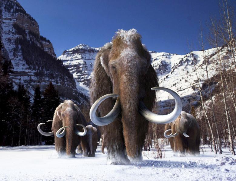
The Ice Age looms large in our view of prehistory. It assumes a world covered in glaciers with primitive humans fighting mammoths or sheltering in caves. Actually, most of our evolutionary history took place in the tropics, far from snow; it was only in the last 40,000 years that our current species, Homo sapiens, found a way into Europe and had to contend with Ice Age conditions.
Then, around 10,000 BCE, the Ice Age ended and global temperatures suddenly increased by about 6°C. This allowed the development of agriculture, which led to villages, civilization and eventually our modern environment.
In this section, we examine more precisely the impact that climate had on our evolution and migration out of Africa into the world.
Index
- The Pleistocene
- Land Bridges
- The GREEN Sahara
- Role of Winter
- Ice Ages in Europe
- Reaching Australia
- Onward to America
Pleistocene: the geological Ice Age
Our whole evolution took place during the Pleistocene, a geological epoch often referred to as the Ice Age that lasted from about 2,580,000 to 11,700 years ago, spanning the Earth's most recent period of repeated glaciations. It was the fifth such Ice Age in the history of our planet.Note that the Pleistocene was not a continuous period of extreme cold; rather it had extreme temperatures alternating beween arctic and tropical conditions. During glaciations ice sheets spread out from the pole and covered the northern parts of Europe and America for tens of thousands of years; but, between glaciations there were interglacial periods with temperatures similar or warmer than our present day. The end of the Pleistocene corresponds with the end of the last glacial period and also with the end of the Paleolithic age used in archaeology.
The charts below show the changes in global temperature over the past 5 million years. [ Ref. Palomar, Utah Geo. Survey].
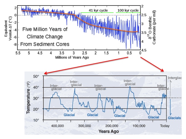
Note that the most extreme climate swings happened in the last 600,000 years, enlarged in the bottom chart. This was the period when our recent ancestors moved north into Europe and their migrations were hampered by the extreme cold.
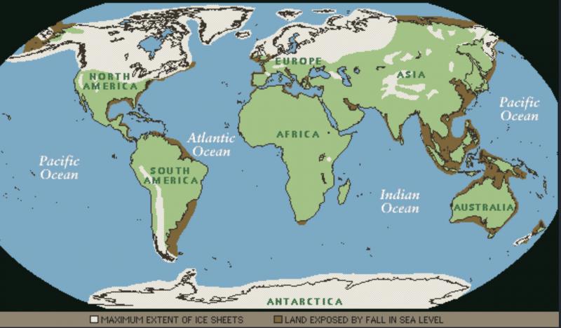
The map below shows the situation during the coldest periods: some glaciers in the northern hemisphere reached the 40th parallel (in America) and covered up to 30% of the world's land mass. Note that England is covered in ice. Surprisingly, Siberia - though intensely cold - is ice free.
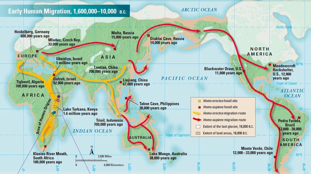
In Africa, where our first ancestors evolved over 3 million years, as well as other tropical zones, global temperatures were almost unaffected. This allowed Homo erectus, our first ancestor to leave Africa around 2 Mya, to proceed as far as China without having to deal with winter conditions. [ See Erectus Migration]
Even though glaciations in the north have little impact on temperatures in the south, they have a huge effect on sea levels all around the world. Glaciations tie up huge volumes of water in continental ice sheets 1500–3000 m thick, and sea levels drop up to 150 m [ Graph ]. This creates land bridges between islands and continents which appear in brown on the map above: Indonesia is connected to Malaysia, New Guinea to Australia, Siberia to Alaska and England to Europe. There were about 30 glaciations during the Pleistocene. This gave early hominins ample opportunity to migrate across these bridges and reach Indonesia, Japan and England. However, Australia and the Americas remained inaccessible: Australia protected by the sea and America by glaciers.
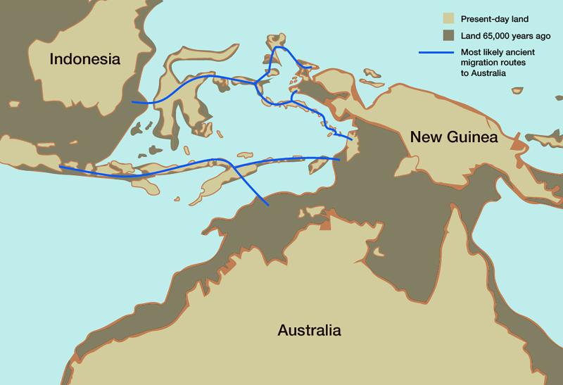
Later, Sapiens will use similar land bridges created by the last glaciation (~40 Kya) to island-hop to New Guinea and walk to Australia and, later, cross over into America.
The map below shows the migration paths followed by successive waves of hominins leaving Africa to populate the rest of the world; first the Middle East, India, Indonesia and China, then north into Europe and south into Australia and finally into the Americas. Note the importance of the land bridges (light brown).
Later, we show better maps of ice-age Europe, Australia and the Bering Strait.
Climate cycles in Africa
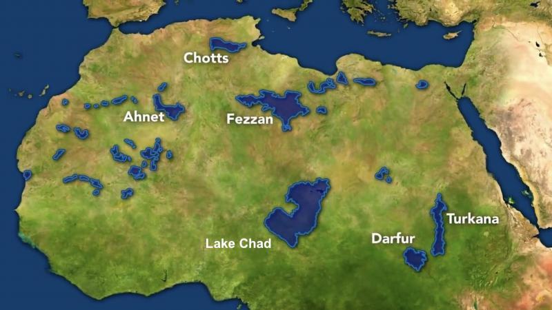
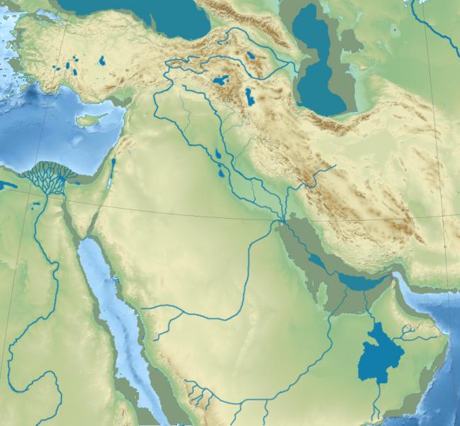
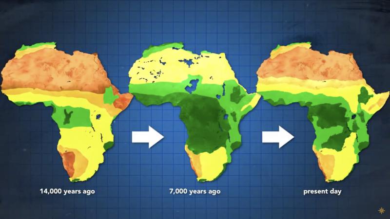
The Ice Age(s) gets a lot of attention; but probably equally important is a different climate cycle that occurs in North Africa. It concerns the Sahara which alternates in a 20,000 year cycle from the extreme desert that we know to a lush GREEN savanna and back again . This cycle also applies to the Arabian Peninsula which gets rivers and lakes. Like land bridges, the periodic greening opens temporary migration paths out of Africa into Europe and Asia.The "Sahara" cycle also affects vegetation on the rest of the continent, as shown on the map below. During arid periods, rainforests south of the Sahara shrink and sources of water such as Lake Victoria dry up. All animals, including our predecessors, would have to change habitats, allowing more adaptable species to emerge.
In particular, the cycle impacted our earliest ancestors who evolved from apes. Initially, they were like small chimps with long arms and prehensile toes: attributes well suited to living on trees in forests (dark green on the map). At various times (like 14 Kya on the map) those forests nearly disappear in favour of savanna (light green) and grassland (yellow). This would give a net advantage to emerging Homo species, with long legs adapted to bipedal motion, who could run fast and travel far on the savanna.In time, Man evolved into a new bigger and smarter species, Homo Erectus, who was able to migrate away from central Africa. Green Sahara periods would allow Erectus to move north and leave the continent via the Sinaï around 1.9 Mya.
Winters
At this point, further expansion north was blocked by climate; not the rigours of an Ice Age but, simply, the yearly occurence of winter. Without fur, and lacking the technology of clothes or fire, H. Erectus could not survive in freezing conditions.So, for the next million years or so, naked Erectus was limited to the warm regions south of the 40th parallel as shown in dark green on the map below. However, this did not prevent him from going east and reaching India, Indonesia and China.
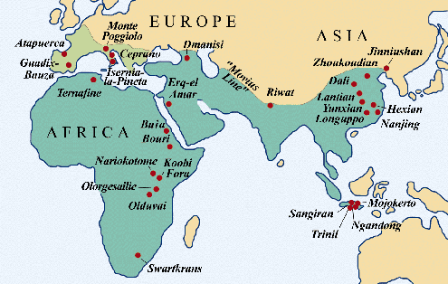
During this period, Erectus continues to evolve independently in isolated areas; but, the total worldwide population remains quite small, never more than 40,000 individuals. As a result evolution, both genetic and technological, is painfully slow. However, fossils show a continuous increase in average brain size and, around 1.5 Mya, Erectus develops a new sophisticated technique ( Acheulean ) to obtain sharper edges on stone tools [ CLICK here more ].
Around 1 Mya, Erectus evolves into a proficient hunter and develops means to cross narrow bodies of water. This allows him to cross into Europe and survive in the temperate southern areas, like Spain - shown in lighter green on the map above - where winters are relatively mild.
EUROPE: learning to survive winter
Western Europe will be the stage for the most dramatic developments in the prehistory of Man.As our hominid ancestors attempted to move north of the Alps, they were blocked by the arctic conditions of recurrent glaciations. Without the ability to start fires, the first arrivals could not survive freezing conditions and would be forced to remain south of a snow line, separating habitable areas to the south from the barren north. This included advanced Erectus variations, known as Antecessor or Heidelbergensis, who were replaced by Neanderthals (from 400 Kya to 40Kya) and, finally, Homo sapiens who arrived around 40 Kya and experienced the end of the Ice age.
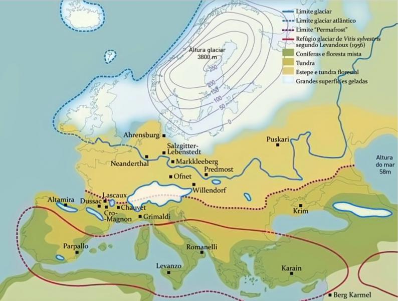
The map below shows the situation during a typical glaciation.
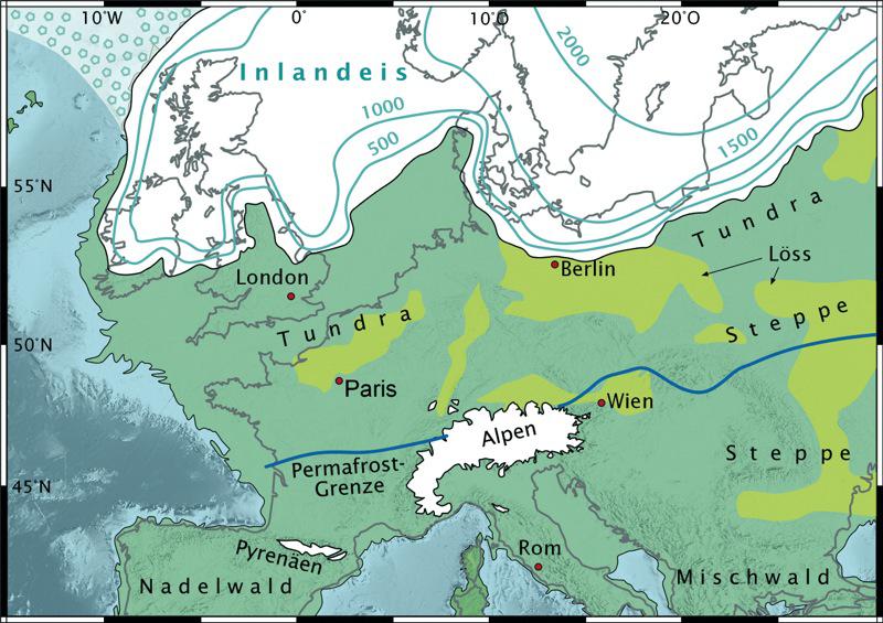
Ice Age in Europe (20,000 years ago)
Although thick glaciers (in white) are limited to the north of Europe; arctic conditions (snow and tundra) extend far to the south. In this case, a Permafrost Border at the level of the Alps shows the northern limit of early hominin activity. In addition, the map shows that lower sea levels during glaciations result in England being connected to the continent.
However, the map shows an extreme situation. During the million years of hominin occupation, glaciations alternated with warm interglacial periods when the glaciers melted and the frost barrier moved north closer to the arctic circle. During those periods, late Erectus and Neanderthals could get much further north: Germany, Scandinavia and even England using temporary land bridges. There, we find evidence of earlier visits: 900 Ky old stone tools in Norfolk, and remains dated 500 Kya in Sussex. However, glaciations recurring every 100,000 years or so, would force these early humans to retreat.
This
MAP shows Erectus settlements north of the extreme permafrost line.
But even at the best of times, in northern regions, early man had to contend with winter
- The first adaptation was genetic: around 400 Kya, late Erectus (Heidelbergensis) evolves into Neanderthals, a stockier hairy species.
- Then came technology: fire, clothes and spears with stone points.
The final chapter will that of Homo sapiens who comes out of Africa around 60 Kya and enters Europe from the Middle East around 40Kya. Coming in the middle of the last glaciation, he would settle south of the permafrost until the end of the Ice Age and that's where we find Lascaux and the other painted caves that testify to his presence around 30 Kya. The map below shows the location of settlements during the last Ice Age (NOTE: Click maps to enlarge ).
Equipped with a better brain and more advanced technology, Sapiens would soon displace the Neanderthals, then move north into Scandinavia and Siberia and cross into the Americas around 15,000 years ago.
Reaching Australia
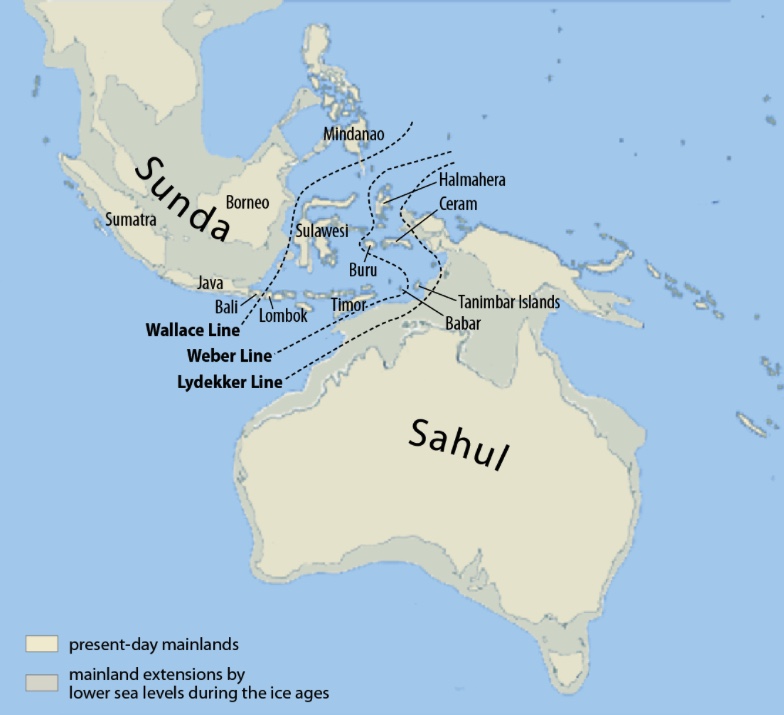
Strangely, it appears that Homo Sapiens reached Australia about 10,000 years before entering Europe. Apparently, it takes time for hominin species coming out of Africa to adapt to cold conditions. It is easier to stay south and move east through India and beyond. Similarly, Erectus stayed south of the 40th parallel for a million years before finding a way into Europe.Leaving Africa around 60 Kya, Sapiens reached Indonesia around 50 Kya. Whereas, Erectus couldn't go much further than Java, With better boat building skills, Sapiens was able to island-hop to the Philippines and New Guinea, eventually reaching the southern tip of Australia around 38,000 years ago.
Conquest of America
During the last Ice Age, Sapiens had acquired the skills and technology necessary to thrive in arctic conditions (like today's Inuit). Hunters following herd of mammoths and reindeer, had moved into Russia, right up to the shallow Bering Strait between Siberia and Alaska. But this Strait is only about 50 m deep, and lowered sea levels of the last Ice Age turned the Strait into Beringia, an ice-free temporary land link to Alaska.This allowed Sapiens to go even further and reach Alaska where further progress was temporarily blocked by the massive ice shield over North America.
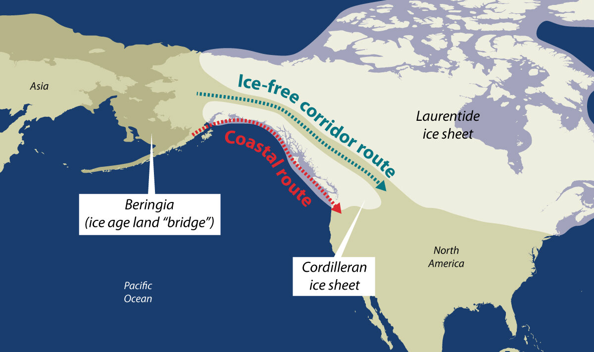
Beringia
Later, when glaciers started to melt, the Beringia bridge disappeared beneath rising sea level; but an ice-free corridor opened up just east of the Rockies. Homo sapiens was able to proceed south and occupy the continent. Within 2000 years, man had reached the tip of South America.
For a long time, the "ice-free corridor", shown above, was the preferred hypothesis for the initial migration south. More recently, a coastal migration route, possibly using canoes, seems more likely. [ Reference ]
Important points
- For the human species, the Ice Age was a good period. Homo sapiens and all his intelligent predecessors - Habilis, Erectus and Neanderthal - would appear during that era.
In addition, the extremes in climate would help our ancestors to populate the world by
creating temporary migration routes.
- During glaciations, lowered sea levels allowed hominins to walk to modern-day islands like England, Indonesia, the Philippines and Japan as well as North America.
- Mild winters during warm periods would open routes around the 45th parallel; giving access to Europe from the Caucasus by the north shore of the Black sea or a route to China via what would become the Silk Road.
- In addition, the Green Sahara periods allowed periodic passage from the Rift Valley to North Africa putting Gibraltar and Europe within reach only 10 miles away. This now appears as the most probable route for the migration of early Man into Europe.
- Later, with cold weather technology - fire, fur and "advanced" weapons - Neanderthals and Sapiens would go further north and roam the Eurasian Steppes - favoured route of the later Mongols - to reach Siberia, the Pacific and North America.
- Nothing indicates that we are past the "Ice Age"; the temperature graphs suggest that we are just in the "warm" phase of a typical cycle; an interglacial that began 11,700 years ago and may start to cool in a few millenia.
- However, human activity appears to have disrupted the normal scheme of things. Scientists tell us that the warming trend over the last century was 10 times faster than in any previous cycle. In any case, massive global climate change as occurred in the past - whether up or down - means that billions of people will need to relocate... eventually !
References
- the Green Sahara Effect

- What Drove Homo erectus Out of Africa? (
Sapiens, oct 2021)

- Last Glacial Period ( Wikipedia )
- 11,700 BP: End of Ice Age ( Younger Dryas )
- Review of Climate Change, Engineering, 2021
